HARRIS
Full length video
Please read Understanding catalogue records for help interpreting this information and Using footage for more information about accessing this film.
Title: HARRIS
Reference number: 7318
Date: 1973
Director: filmed by Archibald W. Ferguson
Sound: mute
Original format: super 8mm
Colour: col
Fiction: Non-Fiction
Running time: 70.07 mins
Description:
An amateur travel film about the island of Harris, including shots of the landscape, local industry, architecture and history.
Shotlist:
[shotlisted from DV - manual control track]
Reel I:
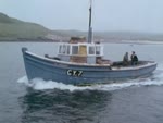
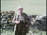
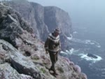
A FERGUS-DIDO TRAVEL FILM - title - Filmed in FERGUSVISION, Colour by DIDOCULLA - PRODUCED BY ARCHD. W. FERGUSON BARRHEAD 1973 - PART 1 - typed caption re geography and industry of Harris (1.10) landscape gvs, Loch Seaforth - c/u shot map showing Ardvourlie Castle, Seaforth island and Loch Seaforth - gvs loch and castle, hills, road (4.01) c/u shot Inverness County Council warning sign 'Ceann an Ora Quarry' - gvs quarry approach, burn, shots of loch and road (4.47) road sign 'Hushinish B887' - c/u map showing Bunaveneadar, wide map of Lewis and Harris showing location - gvs landscape, cottages, shots of river and bridge, dog at roadside - gvs loch and mountains, road, bridges, c/u shots river and rocks (7.04) AMHUINNSUIDHE CASTLE - map of Lewis and Harris showing location - gvs of castle, shots of river flowing into bay, castle gateway, gvs of loch, horses on road and at Ferguson's Mini van, with dog Dido inside (8.14) c/u map showing Husinish - wide map of islands - gvs of Husinish Bay and sandy beach, sand dunes and parked cars (9.27) c/u map showing Scarp - gvs Scarp island, shore and beach, seaweed, caves, breakwater, gvs road up hillside, long shots of mountains and loch (11.30) c/u map showing West Loch Tarbert - sunset shot over loch - c/u road sign 'Tarbert' - map of islands - gvs Tarbert, street, shore - long shot, pan along houses to pier - gvs houses, pier, ferry approaching (12.43) int. gvs captain and crew on bridge of ferry - shots from bridge of ferry approaching Tarbert pier, tying up, c/u shot of captain, cars waiting at pier (14.48) gvs streets and car park at Tarbert pier - gv landscape, road across headland (15.24) c/u map showing Scalpay - wide map of islands - c/u shot burn over rocks - shots of turntable ferry 'Scalpay' leaving slipway - shots on board, then approaching slipway on Scalpay - c/u shot life-belt - gvs bridge and road, bay with houses, people shovelling peat? - gvs Scalpay village: harbour with fishing boats, houses by shore, street scenes (18.52) gvs fishermen mending nets (19.39) gvs pier and fishing boats, creels, boats including 'Ribhinn Donn II', 'Scalpay Isle III', 'Isle of Harris' - c/u shot of cargo of coal on boat - gvs fishing boats (20.57) pan across small bay - gvs Scalpay village, c/u shot Post Office, houses and road, ruined cottages (21.56) l/s Scalpay village - small bay with boats and wrecks - tracking shot from ferry leaving slipway - gvs landscape, road over hills, burn, pan across loch and islands - gvs landscape, loch, roads, hills, croft, bridge, weir, river and bridge - THE END OF PART 1 (24.58) 400 ftc
Reel II:
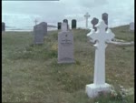
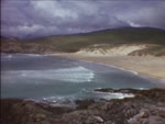
PART 2 - c/u road sign to Drinishader and Scadabay - The GOLDEN ROAD - So named because of its high cost of construction - gv coastline, sign 'Drinishader', map of Harris and Lewis showing location - gvs Drinishader village, caravan on headland, road (1.01) road sign 'Scadabay', gvs village, crofts and road, small bridge, loch and rowing boat - shots of cattle grid over water - road sign 'Grosebay' - gvs road and houses, bay, lochan, gvs coastline, crofts and outbuildings, gvs road, rocky landscape (3.45) gvs burn flowing into loch - gvs of road and bridge over river (4.25) road sign 'Geocrab' - gvs village, road and coastline - road sign 'Manish' - gvs road, village, schoolhouse and coastline (5.36) road sign 'Flodabay' - gvs road, burn, coastline - road sign 'Finsbay' - gvs road, bridge, village, rocky landscape, mountains, crofts (6.56) road sign 'Rodel', gv village - c/u sign 'St. Clement's Church', gvs church and steeple, graveyard, c/u shot restoration plaque - c/u shots architectural details, carvings and windows, burial enclosure, tomb of Alexander Macleod (9.07) gvs road and harbour at Rodel - l/s St. Clement's Church, gvs road and mountains (10.05) road sign 'Leverburgh' - map of islands showing location - gvs village and bay (11.09) c/u map showing Northton - wide map of islands - l/s Northton - gvs street and houses, mountains, gvs sandy beach, flowers and shoreline, bull - gvs village and coastline (13.51) c/u shots jellyfish on shore, pony - gvs sandy beach (14.40) Sheep-shearing at Borve - gv sheep in pens, shots of crofter using hand shears, branding sheep's horns, painting mark with red dye - shots of crofter and boy rolling and bagging fleeces - shots of sheepdog and children rounding up strays at roadside (17.31) gvs of sandy beach and coastline - road sign 'Borve' - wide map of islands - gvs river at beach, hotel? (18.13) Traighs Iar, Nisabost, Seilebost and Luskentyre - gvs coastline, caravan park at beach (19.03) c/u map showing Taransay - wide map of islands - waves on rocks, gvs sunset over sea - THE END of PART 2 (19.59) 298ft
Reel III:
PART 3 - Traighs Iar, Nisabost, Seilebost and Luskentyre - gvs road and coastline, waves on rocks, views across to Taransay (3.01) c/u map showing Seilebost - wide map of islands - gvs croft and landscape, c/u 'Post Office Seilebost' with red telephone box - gvs coastline, beach and mountains - shots of boy and lamb (4.51) woman and toddler feeding lamb from bottle - gv Seilebost Post Office and house, football pitch beside beach, calf, chickens - gvs beach and mountains, road, rabbits in field, sunset over water (7.24) gvs Dido on rocks at shore and sunset over islands (9.03) road sign 'Luskentyre 2' - wide map of islands - gvs beach and coastline, Sound of Taransay, road and landscape (10.40) Leaving Tarbert for Uig, Skye - ferry approaching Tarbert pier - shots on board ferry approaching Tarbert - shots of ferry approaching pier, shot of village and harbour (12.32) shots of ferry 'Hebrides' tying up at pier, passengers disembarking down gangplank, vehicles disembarking and embarking, coach on quayside - gangplank removed and ropes untied - shots of ferry leaving Tarbert (15.01) l/s ferry - shots of sea and landscape from deck of ferry - shots inside bridge of ferry, captain and crew (16.50) shots on deck, funnel and prow - under-exposed int. shots in engine-room (18.30) shots from ferry approaching Skye - shots of ferry approaching Skye - gvs approaching pier at Uig (20.32) shots of cars on ferry - car ramp rising to upper deck - tracking shot from car rising up on ramp to disembark, driving along pier into village (23.40) l/s ferry at pier, shots of ferry departing - focus pull to THE END - I hope you enjoyed the film and found it interesting - Archd. W. Ferguson - A FERGUS-DIDO TRAVEL FILM (25.10) 400ftc