CLYDE VALLEY
Full length video
Please read Understanding catalogue records for help interpreting this information and Using footage for more information about accessing this film.
Title: CLYDE VALLEY
Reference number: 1813
Date: 1972
Sponsor: Educational Films of Scotland
Production company: SEFA (Lanarkshire Group)
Sound: sound
Original format: 16mm
Colour: col
Fiction: non-fiction
Running time: 15.50 mins
Description: The first part of a short series on the River Clyde, studying the geography, social distribution and industry from the source of the river to the outskirts of Glasgow.
Credits:
comm. s. Tom Smith
Scottish Educational Film Association Lanarkshire Production Group John Baird, Charles J. Kerr
Shotlist:
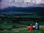
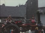
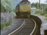
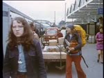
[shotlisted from VHS copy, manual control track]
(0.00) Clyde Valley 1 Clydesdale (0.12) Clydesdale and Lanarkshire scenics (0.38) c/u map showing extent of River Clyde, from Lowther Hills right through county (0.44) gvs southern Clydesdale landscape, blackfaced sheep in fields (1.01) Little Clyde Burn, shot of the Roman path alongside the river (1.15) elevated gvs Beattock Summit, motorway and railway in view - traces of the Roman Road can still be seen to the RHS (1.34) gvs River Daer as it meets the Little Clyde, Daer reservoir including filtration and sedimentation plant (2.24) gvs Elvan Valley and Leadhills, houses clustered in valley, intercut with c/u map showing position of Leadhills (2.40) c/u Scottish Crown, made of Leadhills gold (2.45) c/u sign "Miners Library instituted 1741 by Allan Ramsay" and exts building and street, Leadhills (2.56) c/u signposts "Tombstone of John Taylor", "Alan Ramsey's Institute and Reading Room", "William Symington's birthplace and memorial "(3.06) three boys pan for gold (alluvial gold?) in the stream (3.27) gvs landscape (3.36) brief c/u map of Clyde, gvs landscape between Abington and Biggar, c/u tombstone of Matthew McKendrick, Postmaster, gvs anglers out on river (4.10) shot of Biggar main street (4.14) c/u map showing location (4.20) c/u memorial to Dr. John Brown and brief shot bridge in the town (4.26) archery at Culter House near Biggar, Royal Company of Archers hold annual shoot for the silver arrow trophy (4.59) exts Popinjay Hotel (5.12) m/s Tinto Hill, panoramas from same (5.47) streets, Douglas village, St. Bride's Church, Drumclog near Loudon Hill, Bothwell Bridge (v/o describes Covenanter activity around this area in history) (6.30) open air ceremony. crowds of people take part in conventicle at scene of battle in memory of those who lost their lives for the Covenant (6.44) Aird's Moss near Muirkirk, memorial in middle of field where Covenanters suffered defeat (6.56) slow pan across Lanark skyline (7.04) c/u map showing its location (7.09) gvs Lanark streets (7.21) Lanark Auction Market, cattle market gvs (7.37) gvs Lanimer Day celebrations on crowded streets decked in bunting - date is 11th June (8.33) gvs Bonnington Falls just outside Lanark (8.44) exts hydroelectric station (8.49) Corra Linn The Falls of Clyde gvs waterfall (9.00) New Lanark gvs (9.25) Sir Walter Scott's Tillietudlem Castle exts same and apple orchards (9.43) overview lush lands of Clyde Valley, greenhouses with tomatoes, people gathering raspberries, leeks (10.28) shot of apple trees laden with fruit (10.40) strawberries for sale at the roadside (10.47) brief shot motorway towards Glasgow (10.54) coal bings, slag heaps and gvs coal mine shaft near Shotts, coal buggy running along track filled with coal (11.15) miners exit cage as the day shift comes off duty (11.27) gvs Motherwell (11.43) Colvilles Dalyell steelworks, ints (11.50) Ravenscraig Works, ints sheet steel being created (12.06) Airdrie and Coatbridge street scenes (12.16) c/u map showing locations (12.22) gvs East Kilbride, including exts Civic Centre (12.36) exts Sunbeam Electric, Rolls Royce, Honeywell, Mavor and Coulson (12.47) brief shot Hamilton street scene (12.52) c/u map location, same (12.57) elevated view over Hamilton, and pan to show the County buildings (13.15) exts mausoleum where Dukes of Hamilton were laid to rest (13.21) Cadzow forest gvs and wild white cattle of Cadzow grazing there (13.55) between Hamilton and Motherwell, the area where Strathclyde Park is to be sited (14.07) Bothwell Castle ext very brief (14.14) street scenes, Blantyre (14.20) model of Blantyre village of old (14.27) Shuttle Row, a remnant of the old village. Exts houses, David Livingstone stayed there (14.43) sign 'Blantyre Birthplace of David Livingstone', and further gvs Shuttle Row (14.54) Rutherglen main street (14.59) Dechmont Hill (15.04) view from same, showing Clydesdale (15.08) looking north to City of Glasgow (15.16) montage of Glasgow shots, including University, streets, shipyards (15.30) ecs (15.50)